

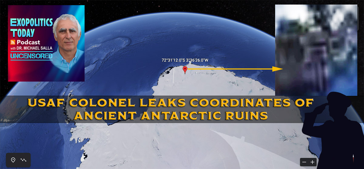
On December 26, 2021, my US Army source, JP, was given a set of geographical coordinates from an unnamed Lt Colonel (USAF) who simply told him to publicly release them. JP had seen the officer at a classified briefing he attended at a military base where he is currently stationed, where he was told about ancient ruins being found on Antarctica, the Moon, Mars, and elsewhere in our solar system.
2021年12月26日,我的美国陆军线人 JP 从一位不知名的美国空军中校那里得到了一套经纬度,中校只是告诉他要公开释放他们。曾经在他现在驻扎的军事基地参加的一次机密简报会上见过这位军官,在那里,他被告知在南极洲、月球、火星和太阳系其他地方发现了古代遗迹。
These were being investigated in joint missions with various Earth nations, including China. JP participated in the Moon mission, which I covered in my previous interview with him, and in an earlier joint mission to Ganymede.
目前正在与包括中国在内的各个地球国家进行联合任务调查。JP 参与了登月任务,我在之前与他的访谈中也谈到了这一点,还参与了早些时候的一次联合 木卫三任务。
The coordinates given to JP (72°31’12″S 3°36’26″W) appear to show a large building complex located about 150 miles (240 km) from the Antarctic coastline in Queen Maud Land. This is an area that was claimed by Hitler’s Third Reich and where an Antarctic Colony, Base 211, was secretly established during World War 2.
JP (72 ° 31’12′ s 3 ° 36’26′ w)的坐标显示,在距离南极海岸线约150英里(240公里)的莫德皇后地有一个大型建筑群。这是希特勒的第三帝国宣称拥有主权的地区,在第二次世界大战期间,一个名为211号基地的南极殖民地被秘密建立。
The ruins are in an elevated area that is ice-free and appears to have a runway or very long hangars from which aerospace vehicles can take off and land.
这些遗迹位于无冰的高架区域,看起来有一条跑道或者很长的机库,航空航天器可以从那里起飞和降落。

Screenshot of the Antarctic Structure. Contrast and brightness adjusted.
南极结构的屏幕快照。对比度和亮度调整。
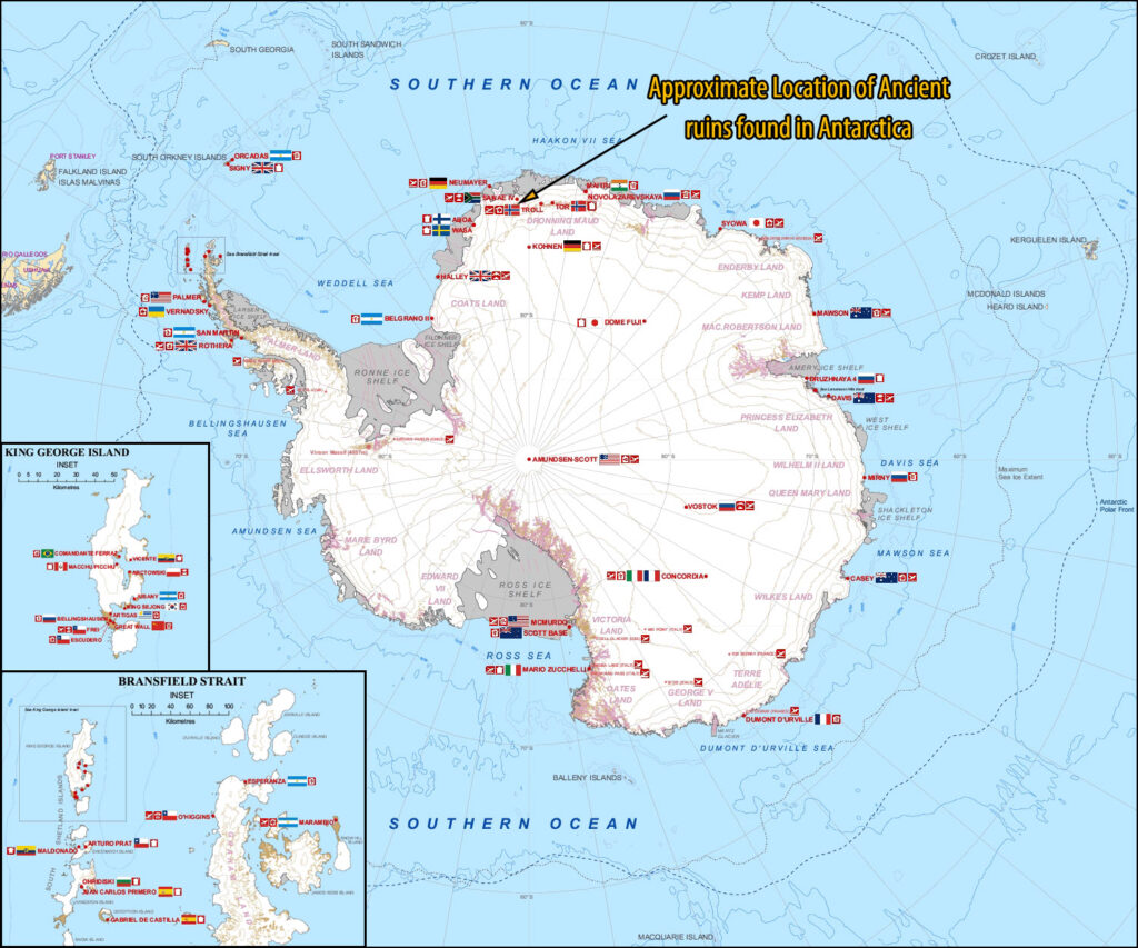
It’s important to point out that the ruins are many miles away from the two nearby Norwegian bases Troll (72°00′42″S 2°32′06″E) and Tor (71°53′22″S 5°09′34″E). These are the two closest Antarctic research stations to the coordinates given to JP, which shows the structure nearly 8 degrees to the west of Troll, with similar latitude. I’ve marked the approximate location of the structure in relation to Antarctic Research Stations in the following graphic.
必须指出的是,这些遗址距离两个附近的挪威基地 Troll (72 ° 00′42′ s 2 ° 32′06′ e)和 Tor (71 ° 53′22′ s 5 ° 09′34′ e)很远。这是距离 JP 坐标最近的两个南极科考站,JP 坐标显示的结构位于 Troll 西部近8度,纬度相近。我已经在下面的图表中标出了这座建筑物与南极研究站的大致位置。
According to JP, the US military is working inside several buildings at the ruins, one of which contains a ‘stargate’ or a ‘portal’ that enables instantaneous travel in our solar system. This is JP’s skype message to me about the ruins:
根据 JP 的说法,美国军方正在废墟的几个建筑物内部工作,其中一个建筑物包含一个‘星际之门’或一个‘入口’,可以在我们的太阳系中实现瞬时旅行。这是 JP 在 skype 上发给我的关于废墟的信息:
These are the ruins where everybody meets up. He is one of the officers. I only saw him once in the rooms that we do the meetings. Came up to me and said to share the information. He works in the building where the gates are that takes you to different places in our solar system. [12/26/2021].
这些是每个人聚集的废墟。他是军官之一。我只在我们开会的房间见过他一次。他走到我面前,说要把这个消息告诉我。他在大楼里工作,那里的大门可以把你带到太阳系的不同地方。[12/26/2021].
Significantly, the USAF Lt Col is said to work in the building where the portal/gate is located. An estimate of the ruin’s size, using Google Earth, is roughly 2500 feet (about 830 meters).
值得注意的是,据说美国空军中校在大楼里工作,大门就在那里。使用谷歌地球估计,该废墟的面积大约为2500英尺(约830米)。
JP created a video that shows the structure on Google Earth for the coordinates he was given and compares its size to Machu Picchu (JP’s video starts at 3:08 in the audio version of this article).
JP 创建了一个视频,显示了谷歌地球上给他的坐标结构,并将其大小与马丘比丘(本文音频版中 JP 的视频从3:08开始)进行了比较。
The location of the ruins suggests that it was found and previously used by the German SSP (Dark Fleet) and was off-limits to the US military. This would have been especially the case if it housed a portal enabling instantaneous travel in our solar system and beyond.
废墟的位置表明,它是被发现的,以前曾被德国的 SSP (黑暗舰队)使用过,美国军方是禁止进入的。如果它有一个能够在太阳系内外实现瞬时旅行的入口的话,这种情况将尤其明显。
It is possible that the ruins were recently handed over to the US military by China. In previous articles I have examined claims that the German Dark Fleet recently had to evacuate Antarctica due to intervention by an Earth Alliance working with friendly extraterrestrial organizations: the Galactic Federation of Worlds. The Dark Fleet facilities were reportedly handed over to China, which quickly handed them over to US Space Command with the provision that joint scientific research would be conducted at these, as stipulated in agreements reached in July above Jupiter, which I discussed here.
这些废墟可能是中国最近移交给美国军方的。在以前的文章中,我曾经调查过一些说法,声称德国黑暗舰队最近不得不撤离南极洲,因为地球联盟与友好的外星人组织合作,即世界之银河联邦联盟进行了干预。据报道,黑暗舰队的设施被移交给了中国,中国很快将其移交给了美国空间司令部,并规定在这些地方进行联合科学研究。
Critics may point to the apparent ruins as merely pixelation due to the low resolution images from the US Geological Survey that Google Earth used for creating the aerial overview. A close examination of the image in comparison to other nearby areas suggests that the object is not due to image pixelation. On Google Earth Pro, a historical review of the coordinates sent by JP show that this is the first time the structure has shown up.
批评者可能会指出这些明显的废墟只是由于谷歌地球用来创建空中俯瞰图的美国地质调查局图像的低分辨率而像素化。通过与附近其他区域的比较仔细检查图像,可以发现这个物体并不是由于图像像素化。在 Google Earth Pro 上,对 JP 发送的坐标的历史回顾显示,这是第一次出现这种结构。
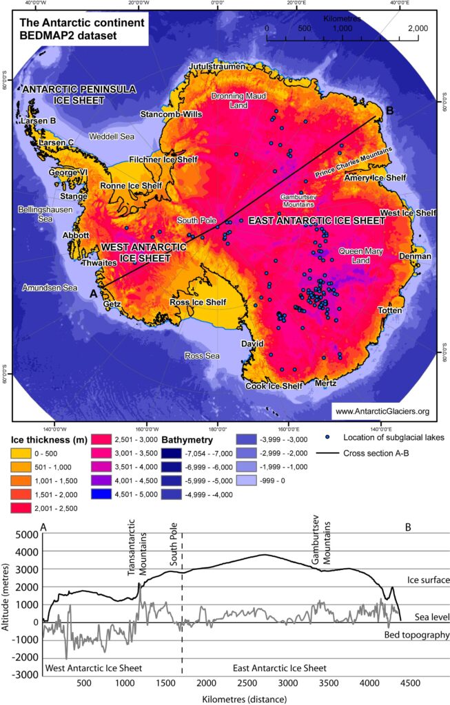
An official graphic from AntarcticGlaciers.org shows that the ice sheet is less than 500 meters thick in the region where the ruins are located. Its location at an elevated ice-free area makes it quite suitable as an airbase that was used by its former occupants—Germans, extraterrestrials, or an ancient civilization.
来自 antarcticglaciers.org 的官方图表显示,遗址所在地区的冰盖厚度不到500米。它位于一个高架无冰区,很适合作为一个空军基地,曾被德国人、外星人或古代文明使用过。
Some may wonder why JP was given the coordinates of these ancient ruins by the USAF officer and told to release it publicly. It is important to point out that in 2017, Air Force operatives, on several occasions, instructed JP on where to look up to the sky to take photographs of flying triangles and rectangles in the vicinity of MacDill Air Force Base. The photos and related articles are available here, here, and more here.
有些人可能会奇怪,为什么美国空军军官给了 JP 这些古代遗迹的坐标,并要求他公开发布。需要指出的是,在2017年,空军操作人员曾多次指示 JP 在哪里仰望天空拍摄麦克迪尔空军基地附近飞行的三角形和长方形。这些照片和相关文章可以在这里、这里和更多在这里找到。
I have high confidence in JP’s reliability as a witness and as a conduit of information releases tacitly approved by senior military officials. This leads me to conclude that the structure found in the Google Earth images may well be ancient Antarctic ruins, significantly larger than those found at Machu Pichu, which was previously used by the German Dark Fleet and is now under the control of an Earth Alliance led by US Space Command.
我对 JP 作为证人和高级军事官员默许的信息发布渠道的可靠性充满信心。这使我得出结论,在谷歌地球图像中发现的结构很可能是古代南极遗迹,比在马丘比丘发现的遗迹大得多,马丘比丘以前是德国黑暗舰队使用的,现在由美国空间司令部领导的地球联盟控制。
A video version of this article is available on YouTube & Rumble
这篇文章的视频版本可以在 YouTube & Rumble 上找到
© Michael E. Salla, Ph.D. Copyright Notice
迈克尔 · e · 萨拉博士版权声明
Michael Salla, Ph.D.
来源:https://exopolitics.org/usaf-colonel-leaks-coordinates-of-antarctic-ruins/
